In combating the dual crises of ecological collapse and catastrophic global heating agroforestry may present a promising and so far under-utilised tool. In the context of the Chew Valley agroforestry is of particular interest and may offer a “win-win”. The win of increased biodiversity, longterm carbon sequestration and continued or even increased food production.
Agroforestry
Agroforestry incorporates trees and other woody perennials within agricultural systems with potentially mutualistic and beneficial interactions between tree and agricultural components. It can offer many economic, environmental and social benefits.
Silvoarable Agroforestry – is the integration of trees and/or other woody perennials within arable farming systems
Silvopasture Agroforestry – is the integration of trees and/or other woody perennials with livestock farming
Although agroforestry has not been well utilised in the UK it is beginning to receive increased attention. Whilst only properly established as a science in the 1970s, the practice itself is thousands of years old and occurs all over the world in many different forms. From tropical home-gardens, to tea and coffee plantations with over-story trees, to the Montados of Portugal utilising cork oak savanahs with grazing pigs, to the walnut and cereal alley-cropping practices in France and Short-Rotation Coppice systems in Germany, agroforestry is a wide-spread and established group of practices, with much greater potential for expansion.
Part of the barrier to wider implementation of agroforestry in the UK is the mindset that trees and agriculture are not friends and should not take place on the same piece of land. Government institutions and funding schemes have reinforced this mindset and woodland remains the domain of foresters and agriculture that of farmers. But trees and agriculture need not be the mutually exclusive competitors they are often considered. Trees on farms, when effectively designed and managed can provide a dirth of environmental, economic and social benefits including: Improved biodiversity and habitat, wildlife corridors joining up otherwise individual parcels of land, reduced soil erosion, increased food security, carbon sequestration, increased nutrient cycling, flood mitigation, increased animal welfare, greater on farm productivity, income and resilience, as well as cultural, social and ecosystem service factors (e.g. oxygen to breath, water and air filtration, wood-fuel and building materials).
Common forms of temperate agroforestry practices that are appropriate for the British climate and farming context included; a) alley-cropping, the planting of rows of trees (food producing trees or trees for timber) and cultivating annual crops in the ‘alley-ways’ between the tree rows, b) silvopastoral practices, where livestock are grazed underneath a tree canopy c) hedgerows, riparian buffers and shelter strips, where trees are utilised to offer an on-farm function such as boundary delineation, wind alleviation, filtration of overland flow, micro-climate creation or wood fuel etc.
Agroforestry offers an opportunity to greatly increase tree cover by planting trees on agricultural land, without taking the land out of production and so provies an alternative/complimentary solution to our ‘oportunity woodland’ methodology, in answering the question of ‘where are the trees going to go?”.
As trees could be planted on arable and pasture land, agroforestry offers an integrated system with a wide range of benefits. If it was embraced by UK farmers what would this do to our Chew Valley woodland opportunity map? The entire map, minus human-habitation and and infrastructure becomes an opportunity for increasing tree cover and as such for:
- Increasing biodiversity, habitat and ecological resilience
- Mitigating and adapting to to climate change, by sequestering carbon in above ground tree biomass and the below ground soil carbon pool and the possibility to provide low input, perennial food crops
- Diversifying farmer incomes while reducing soil erosion, increasing yield and mitigating flood risk
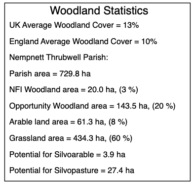
The accompanying parish based maps contain a Woodland Statistics box for each parish that includes an estimate of the area of existing and potential woodland and the areas of arable and grassland in the parish.