Woodland Opportunity Mapping in England
In 2020 Terra Sulis worked with Friends of the Earth to make a woodland opportunity map of England. The map is a first pass at mapping locations that might be considered for woodland creation, given a standard set of constraints. The objectives were to use open data to find areas where there are limited constraints to creating woodland, namely areas that are neither protected, nor prime arable land and which are not on carbon rich peat soils. If we are going to increase woodland* then some other land use has to be replaced. We can’t avoid this, something has to give – but see note on agroforestry below. In our scheme, that ‘something’ is marginal grassland on poor quality agricultural land, generally on Grade 4 (poor quality) and Grade 3b (medium quality on steep slopes) land – see notes below on biodiverse grasslands and peat soils. In England the standard Agricultural Land Classification (ALC) map does not distinguish Grade 3 from 3b, so we made the 3b category according to the ALC specifications (MAFF, 1988) using terrain slopes derived from the Ordnance Survey Terrain-50 data set. The resulting map is not a tree planting plan but it is intended to be the starting point for a conversation about where woodland might be created. This data set has a spatial resolution of 50m which is why the woodland opportunity map looks a bit “blocky”.
*We are using the term ‘woodland’ in the general sense of the Forestry Commission definition, namely areas of land with the potential for a woodland land use. Strictly this means areas managed, or set aside, for trees with an area of greater than 0.5 hectares. Our mapping is based on 50m x 50m pixels which is actually 0.25 hectares.
The full list of constraints (exclusions) is as follows:
- Existing woodland
- Grade 1 (excellent), Grade 2 (very good) and Grade 3 (good to moderate) agricultural land
- Arable land where crops are grown, on any ALC category
- Short term grassland – which is part of the arable rotation
- Semi-natural and potentially biodiverse grassland
- All other priority habitats
- Upland peat soils
- Protected areas, including Special Protection Areas, Special Areas of Conservation, Ramsar Sites and SSSIs
- National and Local Nature Reserves
- Urban areas, non-agricultural land and water bodies
- Scheduled monuments
Criteria for inclusion are:
- Moderate agricultural land on steep slopes, with a Grade 3b land classification
- Poor quality agricultural land with a Grade 4 classification
Very poor quality agricultural land, Grade 5, is generally peat land and is largely excluded.
A difficult task was to identify temporary grassland that was not part of the arable rotation because we didn’t want to encroach onto arable land valuable for food production. This was done using a four year time series of DEFRA Crop Map of England (CROME) data, derived from Sentinel-2 satellite imagery.
Biodiverse Grasslands
Biodiverse semi-natural grasslands are valuable ecosystems and should not be converted to woodland. To identify these grasslands we used the Priority Habitats data layer. Priority habitats capture some of the biodiverse grasslands but our knowledge is incomplete. It is essential therefore to always undertake an ecological survey before thinking of converting pasture into woodland.
Carbon Rich Soils
Planting trees on peat soils is a bad idea because the soil may release more carbon than the trees sequester. There is a lack of openly available soils data in England so we had to use a proxy for carbon rich peat soils. For this we used the Moorline dataset to exclude upland moorland areas where peat soils are generally found. Peat soils also occur in lowland areas, many of which have already been converted to arable land use.
Woodland Opportunity Map
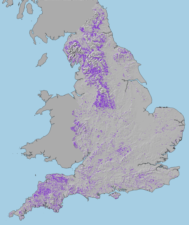
Because, at 50m resolution, the data are quite course, and because our knowledge of both peat soils and biodiverse grasslands is imperfect the map should be regarded as the starting point for a conversation about woodland creation, rather than as a tree planting plan. Use it to focus attention and start a discussion. You can find an interactive version of the map on the Friends of the Earth website. You can also download the data from the data store. This graphic gives a general idea of the distribution.
The general east-west divide between arable and pasture landscapes across the country is evident, with more woodland opportunity (purple) on the western side. The eastern side of the country may benefit more from trees as part of agroforestry systems.
Agroforestry
Of course, trees already exist in many arable landscapes as individual trees in hedgerows or as lone standards in fields. There is scope to increase tree cover in arable areas as part of agroforestry systems rather than as woodland. Agroforestry has many potential benefits and is not limited to the areas on the map above. Agroforestry can be applied in the blank areas of the opportunity map but it is difficult to map these areas per se, although it is possible to say how many trees might be introduced to both arable and pastural landscapes.
Natural Regeneration (Rewilding) Opportunity in England
Based on a groundbreaking paper by Broughton et al. (2021) this map is a subset of the woodland opportunity map and highlights those areas that are both in the woodland opportunity zone and which are also in close proximity to woodland seed sources and which may be suitable to set aside for natural regeneration – aka ‘passive rewilding’. We developed this version of the map in collaboration with Friend of the Earth and Rewinding Britain.
Parish Based Maps
We have experimented with producing parish based map atlases, bringing together useful information including woodland opportunity and land use to help plan woodland creation interventions at the community level. These are currently only available in the Chew Valley.
References
- Broughton RK, Bullock JM, George C, Hill RA, Hinsley SA, Maziarz M, et al. (2021) Long-term woodland restoration on lowland farmland through passive rewilding. PLoS ONE 16(6): e0252466. https://doi.org/10.1371/journal.pone.0252466
- MAFF, 1988, Agricultural Land Classification of England and Wales, Revised guidelines and criteria for grading the quality of agricultural land. Ministry of Agriculture, Fisheries and Food.